November ends on a comparative warm note for various parts of India. National capital New Delhi experienced the warmest November in the past six years with the average maximum temperature of 28.8°c highest since 2016, when average maximum in month of November was 29.6°c.
Overall India recorded a warm November as maximum temperatures were reported above normal for most days in various regions.
The observed average maximum, average minimum and mean temperature for the country as a whole during November 2022 are 29.3°c, 17.69°c and 23.5°c respectively, against the normal of 29.0°c, 17.4°c and 23.2°c based on the period between 1981 till 2010. Thus, the average maximum temperature, average minimum temperature and mean temperature are above normal by 0.3°c, 0.2°c, and for the country as a whole 0.3°c respectively.
As per the records of the Indian Meteorological Department, East and North East India experienced the warmest ever November since the record keeping begin in 1901, the average maximum temperature in the region was recorded as 29.6°c against the normal of 27.79°c, broken the previous all time record of 29.04°c from November 1979.
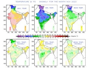
The reason behind historical high temperatures was longevity of dry weather across the North East India in the month, a significant below normal rainfall during the North East monsoon resulted in higher day time temperatures.
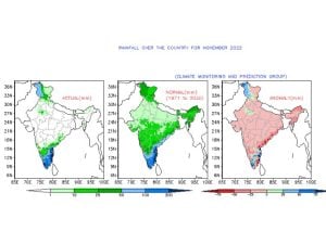
Rainfall over the country as a whole for the month of November 2022, it has recorded 18.7 mm, which is 37% less than its Long Period Average (LPA) of 29.7 mm. Rainfall over the homogeneous region of East & North East India (0.4 mm) was the lowest since 1901. Rainfall over the homogeneous region of Central India (0.4 mm) was the fifth lowest since 1901. Prior lowest rainfall years:
2011 – 0.1mm
1957 – 0.2mm
1920 – 0.3mm
1970 – 0.3mm
1952 – 0.4mm
The past week has been considerably dry even in the southern parts of India which usually gets rains around this period due to active North East Monsoon conditions, lack of tropical disturbance in the bay of Bengal keeps the south drier than usual.
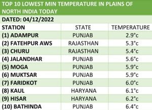
Absence of western disturbance in the north India is keeping the Himalayas and plains bone dry from the past fortnight resulting in higher day time temperatures across the region. Meanwhile the minimum temperatures are maintaining near normal at both hills and plains, Adampur in Punjab registered 2.9°c, making it the coldest stations in the plains on Sunday morning by recording the the lowest minimum temperature.
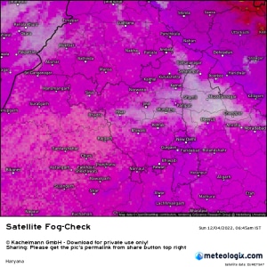
Along with the absence of western disturbance the seasonal fog has not showed up in the plains during the past week, once the fog formations starts maximum temperatures start dipping in the Punjab, Haryana, Rajasthan, Delhi NCR, Uttar Pradesh this has been missing so far but on a layer of dense fog was observed of parts of Punjab, Haryana and Uttar Pradesh hinting for the change in weather conditions next week onwards.
Following the trend of previous weeks, mainly dry and clear weather continues to dominate most states in Central, East and North East India.
Subdued rains in South India resulted in fall in overall rainfall numbers in the country but the departure from normal is holding above the normal category.
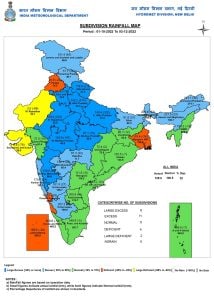
In the period of 1 October till 3 December, India received 129.8mm rainfall against the normal of 106.5mm, a departure from normal stands at +22%.
Subdivision wise seasonal rainfall figures:
• Southern Peninsula: Actual 241.9mm against the average of 246.7mm, -2% departure from normal.
• East & North East India: Actual 165.2mm against the average of 146.86mm, +13% departure from normal.
• North West India: Actual 79.5mm against the average of 34.2mm, +132% departure from normal.
• Central India: Actual 93.6mm against the average of 71.6mm, +31% departure from normal.
Current synoptic features influencing weather in India as on 4 December:
• The western disturbance as a trough in middle and upper tropospheric westerlies with its axis at 5.8 km above mean sea level roughly along longitude 67°E to the North of latitude 25°N persists.
• A cyclonic circulation lies over South Andaman Sea & adjoining equatorial Indian ocean-Strait of Malacca and extends up to 5.8 Km above mean sea level. Under its influence, a low pressure area is likely to form over South East Bay of Bengal & adjoining South Andaman Sea by 5 December. It is likely to move West- North Westwards and concentrate into a depression over South East Bay of Bengal by 7 December morning. Thereafter, it is likely to continue to move West- North Westwards and reach South West Bay of Bengal near north Tamil Nadu-Puducherry & adjoining South Andhra Pradesh coasts by 8 December morning.
All-India weather forecast till 10 December:
The dull week in terms of weather activities in India is about to end as we head next week, upcoming days are all set be interesting with fog and typical winter feel setting in the northern parts of the country while there is high probability of a cyclone developing in bay of Bengal and impact states in South India with heavy rains and strong winds will be a sudden turn of the events within a week.
South India:
The weather conditions will be mainly dry in Andhra Pradesh, Telangana, Karnataka, Goa for the next 3-4 days, till Wednesday parts of Tamil Nadu and Kerala will observe subdued rainfall activities.
Weather models are in fairly tight agreement in formation of the low pressure area over South East bay of Bengal by Monday evening while moving North Westwards it is very likely to concentrate into Depression over South East bay of Bengal by the morning of 7 December.
Additionally the presence of Kelvin wave and the potential arrival of MJO in a couple of days time over Indian Ocean is another factor that could not be ignored while trying to summarize the life cycle of the upcoming disturbance. The passage of MJO over Indian Ocean increases the probability of the upcoming disturbance intensifying into a marginal cyclone though question marks will remain on the intensity at the time of landfall.
Whether the system makes landfall as cyclone or a deep depression, most parts of Tamil Nadu, South Andhra Pradesh to experience very heavy to extremely heavy rains in the period of 8 to 10 December, specifically coastal areas to experience strong winds, storm surge and high risk of flooding.
As the system moves inland moderate to heavy rains are expected over Bangalore, parts of Karnataka and Kerala during 9 to 11 December.
After a prolonged spell of below normal rains for two weeks, a week is finally set to kick in the southern peninsula with excess rains.
North India:
The slow transition towards winter is picking up pace with dense fog seen in parts of Punjab, Haryana and Uttar Pradesh on 4 December, despite the absence of western disturbance there is abundant moisture present in the plains of North India, also slow wind speed during the nights can favor the expansion of dense fog across Punjab, Haryana, Delhi NCR, Uttar Pradesh and North Rajasthan during the upcoming week, even if the fog stays till morning hours it will result in saturated atmospheric conditions, eventually the day temperatures will start decreasing to the normal levels in the next week, most stations to start recording maximum temperature in the range of 20 to 25°c in the period of 5 to 10 December.
Minimum temperature will continue to play around normal ranges while maximum temperature will start shifting towards normal temperature ranges over the next week,
In absence of the western disturbance Himalayas to stay snow free for another week also rains will not be visiting plains anytime soon.
Central, East and North East India:
Following the trend of the previous weeks, dry and clear weather conditions are likely to prevail across the Central, East and North East India in the upcoming week.
Dry and slightly warm afternoons and cool nights are expected in Gujarat, Maharashtra, Madhya Pradesh, Chhattisgarh, Bihar, Jharkhand, Odisha, West Bengal and states of North East India till 10th December, maximum temperatures will remain in the above normal category for another week while minimum temperatures will remain around normal.
Expected range of minimum and maximum temperature in the States till 10 December:
• Punjab: 3 to 10°c, 20 to 25°c.
• Haryana: 5 to 11°c, 22 to 26°c.
• Delhi NCR: 7 to 12°c, 23 to 27°c.
• Uttar Pradesh: 7 to 12°c, 23 to 28°c.
• Rajasthan: 3 to 13°c, 25 to 31°c.
• Gujarat: 8 to 17°c, 26 to 34°c.
• Madhya Pradesh: 6 to 12°c, 26 to 33°c.
• Maharashtra: 8 to 18°c, 28 to 36°c.
• Chhattisgarh: 7 to 14°c, 27 to 33°c.
• Bihar: 7 to 12°c, 25 to 31°c.
• Jharkhand: 8 to 14°c, 27 to 32°c.
• West Bengal: 10 to 18°c, 28 to 34°c.
• Odisha: 9 to 15°c, 28 to 34°c.
• North East India: 3 to 14°c, 21 to 34°c.
The author, better known as the Rohtak Weatherman, interprets and explains complex weather patterns. His impact-based forecasts @navdeepdahiya55 are very popular in north India.
Read all the Latest News, Trending News, Cricket News, Bollywood News,
India News and Entertainment News here. Follow us on Facebook, Twitter and Instagram.
from Firstpost India Latest News https://ift.tt/VvjlEiX
No comments:
Post a Comment